Drone technology has revolutionized the field of surveying, offering faster, safer, and more cost-effective data collection methods than traditional techniques. However, one of the most significant advancements that has elevated drone surveying to new heights is rtk gps—Real-Time Kinematic Global Positioning System. In this article, we’ll explore how RTK GPS improves drone surveying accuracy and why it’s become a vital tool for surveyors worldwide.
What is RTK GPS?
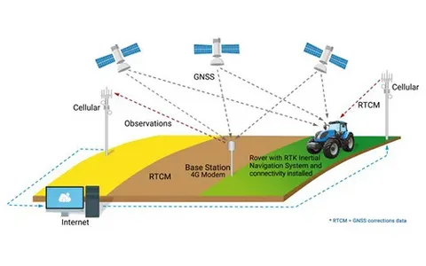
RTK GPS is a satellite navigation technique used to enhance the precision of position data derived from satellite-based positioning systems such as GPS, GLONASS, Galileo, or BeiDou. Unlike standard GPS, which typically offers meter-level accuracy, RTK GPS delivers centimeter-level precision by using a fixed base station and a moving receiver (the drone) to correct positional errors in real-time.
Limitations of Traditional GPS in Drone Surveying
Traditional GPS systems used in drones often fall short when it comes to high-precision tasks. They can suffer from errors due to atmospheric disturbances, satellite geometry, and signal blockages, leading to inaccuracies that range from 1 to 5 meters. For applications like construction planning, topographic mapping, and precision agriculture, this level of error is unacceptable.
This is where understanding how RTK GPS improves drone surveying accuracy becomes essential.
Key Benefits of RTK GPS in Drone Surveying
1. Centimeter-Level Accuracy
The most obvious advantage of RTK GPS is the dramatic improvement in positional accuracy. With real-time corrections, RTK-enabled drones can achieve precision levels within 1–2 centimeters—making them suitable for applications that require high fidelity in spatial data.
2. Reduced Need for Ground Control Points (GCPs)
In traditional drone mapping workflows, ground control points are critical for ensuring spatial accuracy. However, setting up GCPs is labor-intensive and time-consuming. RTK GPS significantly reduces or even eliminates the need for GCPs, saving time and improving operational efficiency.
3. Real-Time Data Correction
RTK GPS processes corrections in real-time, meaning surveyors can view high-accuracy data during the flight itself. This allows for immediate decision-making, reduces rework, and increases the reliability of field operations.
Use Cases That Highlight How RTK GPS Improves Drone Surveying Accuracy
From construction site modeling to utility inspections and precision farming, the implementation of RTK GPS in drone systems has transformed how spatial data is collected and utilized. For instance:
- Civil engineers use RTK drones to monitor infrastructure development with high accuracy.
- Agronomists rely on RTK precision to optimize crop management and irrigation planning.
- Surveying professionals now complete large land assessments in a fraction of the time without sacrificing accuracy.
These real-world examples clearly demonstrate how RTK GPS improves drone surveying accuracy and enhances productivity across multiple industries.
Conclusion
As drone surveying becomes more prevalent, the demand for higher accuracy continues to grow. RTK GPS addresses this need by delivering centimeter-level positioning in real time, eliminating many of the limitations associated with traditional GPS technology. Whether you’re mapping a construction site or surveying agricultural fields, understanding how RTK GPS improves drone surveying accuracy is key to achieving better results, faster and more efficiently.


